I’ve always loved boats of all sorts as well as wilderness travel, and combining both into a wilderness river canoe trip is for me the most relaxing and ideal way to spend extended time in the wilderness. The canoe carries all of the gear, the river helps carry the canoe, the scenery and wildlife roll on by, making for very enjoyable experience.
The Green River starts in Wyoming, runs most of the way through Utah and joins with the Colorado in southern Utah. The 110 miles from the town of Green River to the confluence with the Colorado River are for the most part free of any rapids, and are easily run in a canoe.
Sharon and I decided to float 68 miles over 9 days from the town of Green River, through Labyrinth Canyon, to the Mineral Bottom take out point. Many people do it in 4 or 5 days, but we wanted to allow ample time for day hikes and exploring.
We rented the largest canoe that Moab Rafting and Canoe company offered, the Wenonah 18.5 fiberglass canoe. Weighing only 56 pounds, its quiet, lightweight, and a joy to paddle even with heavy loads.
And we did have a heavy load – we brought along 2 camp chairs, table, 70 quart cooler, dry box with a lot of canned goods, Pelican case of camera gear, and 20 gallons (160 pounds) of water.
The water was the heaviest part of the load. The outfitter recommended against filtering river water, although I brought along alum and a gravity filter, along with Aqua Mira as backups. Turns out we needed it!
Day 1
Fully loaded and heading out.
We arrived at Green River State Park around 11 AM and were on the water by 11:30 AM. Chance, our shuttle driver, helped us rig a balanced boat and strap everything down. We didn’t have any plans to capsize, but if we did, the strapping would at least save us from scrambling after 7 dry bags, cooler, etc.
The first thing we saw after crossing under the I-70 Bridge was a bloated mule deer buck with a full rack laying on his side in the middle of the river. Not an auspicious beginning!
The wind started to kick up as well, and we were soon paddling into consistent 15 knot winds which would persist for the next few days. It was good exercise and practice.
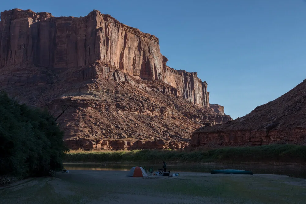
Because of our late start, we got in only 10 miles before stopping for the night at our first campsite – on a moderately steep bank with a shelf wide enough to accommodate our two person tent. The site also served up hordes of ants and a lot of thorns, but the tamarisk was thin in this section of the bank, and we were able to hike up into the desert after dinner and watch the sunset. We also had our first of many daily swims in the river to cool off.
First camp with our friends the ants and thorns.
Day 2
We were on the river by 9:30 AM, and paddled 17 miles, mostly into moderate headwinds,
We were lucky enough to catch Crystal Geyser erupting. This riverside attraction has a curious history. In 1935, an oil exploration company drilled a hole right by the river, and struck carbonated water instead of oil. Now, the hole occasionally erupts with carbonated water, created strange mineralized deposits below.
Having a drink at Crystal Geyser. Don’t try this at home kids!
We paddled hard the rest of the day, and took out at mile 93 at Bull Bottom. We camped on a very wide, sandy beach, with expansive views north and south. The tamarisk was very thick here, and we were unable to get up the riverbank into the desert for our evening walk, so we settled for walking up and down the sandbank.
Tamarisk is not native to the region. It was imported as an ornamental and escaped into the wild. In the last 90 years it has choked out most of the native vegetation along the entire length of the river and formed a mostly impenetrable hedge. The tamarisk beetle was imported from Asia in 1994, and has been slowly working its way down the river, replacing a living impenetrable hedge with a dead impenetrable hedge. Eventually though it should be much less of a problem.
This was an amazing night for stars. The Milky Way came out as plain as day, and we sat in our lounge chairs just watching the stars (and satellites). Seems like there more satellites every year, and with sky link coming on with 22,000 satellites, the night sky will be looking pretty crowded. Even now, many days after our trip, Sharon talks about her “oh my god” moment when taking a bathroom break in the middle of the night and looking up at the Milky Way.
Day 3
We were on the river again at 9:30. We put ashore at Trin Alcove Bend and hiked up to the top of the Butte. It was an easy 20 minute hike up, and there were great views on both sides of the bend in the river. Far upriver we could make out a party of five canoes and one kayak. These were the first people we had seen on the river. We bumped into them when returning to our boat, and they told us they were paddling to the confluence, another 85 miles downstream, in only five days. This kind of timeline means a lot of paddling and no time for exploring off river.
View upriver from Trin Alcove Bend
Great blue herons continued to appear feeding in the shallow water about every mile or so, and were regular companions for the rest of the trip.
Our constant companions - the Great Blue Heron.
The other regulars were ravens, who were usually visible riding the thermals in the side canyons, or calling back and forth to each other. Speaking of birds, floating gave us ample time to bird watch, and we made this list:
Gray Flycatcher
Woodhouse Scrub Jay
Great Blue Heron
Raven
Canada Goose
Common Poorwill
Snowy Egrets
Blue Wing Teal
Brewers Sparrow
Canyon Wren
White Face Ibis
Wilson’s Warbler
Says Phoebe
Mallard
Turkey Vulture
Robin
There were a number of other species that I never could identify, but perhaps on the next trip!
Our camp for the evening at mile 81 had a nice grove of oak trees on a flat bench for hiking.
Day 4
We got our earliest start yet, 9 AM. It turns out that setting up and breaking down a camp with table and chairs, propane stove, toilet, cooler, and a canoe to be rigged takes more time than our usual ultralight backpacking approach. 9 o’clock was about the earliest we would get out of camp the whole trip. We weren’t getting out of the tent much before 7 AM though.
Speaking of toilets, the BLM and the National Park Service both require all human waste be packed out because too many people float the river and use the same campsites. So we carried a 30 caliber Army surplus ammo can with an eco-safe waste box inside it, and a special toilet seat that fit on top. We set that up when we arrived in camp, and took it down every morning. The toilet always had a great view, but we were camped on sandbanks in full view of anyone upstream or downstream. Fortunately, travelers were few and far between.
Paddling into wind and some chop
We stopped at the Denis Julien inscription at mile 74.5 on the left bank, just below an old mining road. Denis was a trapper who traveled the area in the 1830s, well into his 60s. His main claim to fame was his propensity to inscribe his name in various places. But it’s a cool piece of history as well, imagining this crusty old trapper traveling alone in these remote canyons.
Denis Julien, 1836
We camped for the evening at the beginning of the Bow Knot saddle, at mile 69.9. During the day, we had seen dry lightning and what looked like rain off to the north, along with increasing gusts of wind, which made paddling more difficult. After dinner, the wind started to pick up and then the storm hit full force.
First to go was the tent, which pulled up stakes and started to blow away. Sharon grabbed it and held it down while I struggled to stake it down with longer stakes and then to weight the stakes with heavy items from camp. The wind was blowing over 50 miles an hour, and the air was filled with water and sand making visibility through our streaming eyes difficult.
With the tent secure we turned our attention to the rest of camp, putting everything back into dry bags and tying it all together.
The canoe we thought was safe enough, pulled up away from shore, with 80 pounds of water jugs sitting on the bottom.
We climbed into the tent and spent the next four or five hours trying to keep the wind from completely crushing the tent. At times a gust would hit and flatten it down, so to reduce the strain on the poles we braced with our feet. We didn’t have enough long sand stakes to guy out the fly which would’ve helped a bit.
Sometime after midnight the wind moderated a bit, and I went out to check on camp. I pointed my headlamp at our gear and could see that it was all still there, but when I turned the headlamp to where the canoe should be, there was just an empty patch of sand! The wind had rolled our canoe into the river, along with three of our water jugs, fire pan, bailing bucket, and all three canoe paddles. I waded up and down river in the middle of the storm trying to make out some sign of our gear. The wind was strong enough that I thought it actually could have been carried up river, but there was nothing visible within the few hundred yards I was willing to go.
I sent the outfitter and a friend in Seattle a text message via our Garmin inReach mini (a satellite emergency device), notifying them of the loss of the canoe and asking for ideas on how to proceed. I was hoping the outfitter would be able to get another canoe downriver to us (after paying him about $3500 for the lost gear!).
I also spent some time kicking myself over failing to better secure the canoe. It was ignorance on my part, but I felt like I should have been better prepared.
Then we went back to a fitful few more hours of sleep.
Day 5
The morning after the storm - most of our gear still there - but no canoe!
Breakfast was a somber affair. We were stuck until the canoe showed up. We had not yet heard anything from the outfitter. I decided to wade and swim down river to look for lost gear. Sharon and I talked about safety and risks - how far would I walk, what issues might occur, the time would I be back, and how to continue working with the outfitter. We decided I would move a couple of miles downstream, and be back within five hours.
I headed downstream with a pack with water, sunscreen, and energy bars. It was surprisingly straightforward - most of it I could wade up to chest deep, and a few sections I had to swim, but the water wasn’t that cold and the sun was out. I did exit the river on to a cattle trail for one stretch which looked like a long swim. When I returned from the cattle trail, I saw what looked like a piece of yellow garbage on the bank, but when I went to pick it up, I realized it was the inflator sack for our mattress pads. It had blown away in the storm and we hadn’t missed it yet. Talk about karma - going to pick up someone else’s garbage and discovering it was your own gear!
I continued downstream for another mile or so, and then far downriver could barely make out some object partially submerged in the middle of the river. As I got closer I could see the green hull of our canoe! I whooped for joy and started splashing downstream. When I finally reached the canoe, I could see it was full of water and would be difficult to move. It had hung up in a slightly shallow area mid-river, but as I tried to shift it the wind and current started taking it downstream. I realized I needed to bail it out before I could move it upstream, as even getting it to shore seemed like a risk. Fortunately, I had found the yellow inflator sack, which turned out to be the perfect bailing instrument, taking about 3 gallons of water per scoop.
Yes, that’s our canoe!
With the canoe mostly free of water, I turned back upstream, happy that at least I would not be buying a new canoe for the outfitter. However, without a paddle, we still weren’t going anywhere. Perhaps I would be able to borrow one from some passing river party, as each party is required to have at least one spare paddle. Or perhaps we could use poles and pole our way down through the shallow sections. As I approached the section of river where I had walked on the cattle trail, I spotted one of our paddles on the shore! The only section of riverbank I had bypassed going down river contained one of the missing paddles. With this find, our trip was now back on track. We had only one paddle, which would make paddling into the wind difficult but not impossible. And we had only one 5 gallon jug of water, but our gravity filter would make up the loss.
Sharon was equally relieved when she spotted me moving up river with the canoe. We informed Kevin, the outfitter via our inReach (who it turns out was waiting for our go-ahead to paddle another canoe downriver to us), packed up camp, and spent the rest of the day paddling downstream, scanning both banks with binoculars for missing gear. I spotted a bit of blue on the surface on river right which turned out to be one of the 5 gallon water jugs. A mile later we found one of our collapsible 5 gallon water jugs. A bit further on we came to an island, and split up. Sharon walked the island while I took the left channel. I found our missing boat sponge and rejoined Sharon at the downriver side of the island.
We finally camped at mile 63 on another beautiful sandbank, within sight of the Bow Knot saddle on the down river side.
Day 6
We woke up in the morning knowing that we needed to continue searching for a paddle while proceeding downstream as quickly as we could to avoid missing a rendezvous date with the outfitter at Mineral Bottom. With only one paddle, we couldn’t take a chance on the wind coming up and blocking our progress downriver. We broke camp and were on the river by 9:30 AM.
We did treat ourselves to the luxury of a hike up to the Bow Knot saddle, which we couldn’t do the prior day. The river does a 180 loop here, and by standing on the saddle you can see both legs. The trail was reasonably well marked with cairns, and the view at the top of both sides of the river was outstanding.
Looking up and down river at Bow Knot bend.
Continuing a bit further downriver, we headed to river right to assess whether we could afford to do a long day hike up Two Mile Canyon, onto the mesa above, and around to Five Arches. As we approached the bank, we spotted another one of our paddles! Ironically, the paddle had washed ashore in an eddy, and had we not steered right to do the hike, we would have never found it. Now we could afford to do the hike and relax about keeping to our schedule for the rest of the trip.
The 2 Mile Canyon hike was our favorite hike of the trip. It was about 1.5 miles and 2.5 hours up, and 2 hours back. Although the heat was brutal switch-backing up the canyon, and the route finding on the slick rock tricky at times, the Five Arches were breathtaking. They formed a large cathedral, and you could sit inside and look out over Labyrinth canyon. Note that the USGS map position for the arches is off by about 1000 feet, while Gaia GPS is off by only 300.
Five Arches at the top of the mesa above 2 Mile Canyon.
We were so exhausted by the end of the hike that we settled for a cold soup dinner at the first available campsite on a sandbar at mile 60. We staggered around the camp like zombies, no chairs, table or stove set up, and went to bed early.
Day 7
And on the seventh day, we rested. We didn’t break camp until one in the afternoon, and Sharon took stern seat to work on her paddling and steering skills. We stopped at horseshoe Canyon and found a small petroglyph on the downriver canyon wall. It was a hot day, with no wind, and where we could, we paddled in the shade of tamarisk on the bank.
At one point we came within a few feet of a pair of beavers, and I don’t know who was more startled, but they disappeared into the water with loud splashes. After 5 miles, we camped at mile 55. Our take out point was Mineral Bottom, at mile 52. We planned on spending the next day hiking, with an easy 3 mile paddle the day after.
As we did most other days, we went swimming twice, with Sharon practicing her river crossing and current gauging skills while swimming.
In the evening, Jupiter rose over the canyon rim, and we could make 5 of its moons with our binoculars. Saturn appeared shortly thereafter, and I took this nice photo of our tent in the foreground with the Milky Way, Jupiter, and Saturn in the sky overhead.
Day 8
This was our only layover day where we didn’t have to pack up camp in the morning. We had a leisurely breakfast, and then paddled right across the river to Hell Roaring Canyon. A few hundred yards up on the right was another inscription by Denis Julien - this time with some artwork depicting mountains and the rising sun.
We hiked a few more miles up the canyon, and came across four bighorn sheep - two females and two youngsters. We spent about 10 minutes watching them, as they didn’t seem to know what to make of us. They grazed a little closer, then a little further away, and then finally decided to run furiously up and across the hillside around us. After examining their tracks, we figured out that the numerous tracks we’d seen coming down river were actually sheep, and not mule deer.
Day 9
Last day! Another leisurely morning, and then slow drifting downriver, and before we knew it we were at the take out. Too soon! We were both ready for another 9 days.
I was curious to meet some of the other folks who were taking out or putting in.
There was another group starting their trip down through Cataract Canyon to Lake Powell in four whitewater rafts. I asked questions and eyeballed their gear, as Sharon and I have purchased a raft and plan on doing similar trips next year. One of them was carrying a 4hp outboard which they planned to use to tow the rafts through the long flatwater stretches. That sounded awful to me. I would rather put the arm work in and listen to the birds than listen to an outboard motor.
Dougy and Shane had an interesting story. Dougy had seen a YouTube video in January about building your own canoe, and then built his own canoe and took it down the Green River with his friend Shane for its maiden voyage, having never canoed before! I was very impressed with his willingness to dive into the project. We passed an amiable couple of hours with Dougy and Shane, who it turns out were riding on the same shuttle van with us back to Moab.
Kevin, the owner of Moab Rafting & Canoe Company, finally arrived, and we endured some mild pointed questions about how we had managed to lose his canoe, before we loaded everything up and headed back to town. After nine days without Internet, cars, or people, it was a bit of an adjustment. But the take out from the local barbecue joint helped ease us in.
This is still one of my favorite wilderness trips, and Sharon and I look forward to doing the next 48 miles from Mineral Bottom to the confluence, perhaps next year.
Resources
Guide to the Colorado & Green Rivers in the Canyonlands of Utah & Colorado. If you bring one reference, bring this. River map, hiking suggestions, history, and natural history in one waterproof booklet.
River Guide to Canyonlands National Park and Vicinity. Michael Kelsey has seemingly hiked into every obscure canyon, and interviewed every old timer to come up with this books on the region.
Moab Rafting and Canoe Company’s Labyrinth Canyon page, and their packing list.
Filtering water
We heard conflicting information on whether to filter Green or Colorado River water for drinking, versus carrying enough for all 9 days. The longer you are out, the more water you have to carry, so I spent a lot of time researching approaches and creating a solution that worked for us. The main issue is the very fine silt in the water – it will clog up a filter in no time. The solution is to mix some Alum into a bucket of river water, and then wait 4-8 hours for the alum to bind to the particulates and settle to the bottom. Once that’s done, the actual gravity part takes about 20 minutes for 2.5 gallons, with no pumping. Here’s my setup:
Materials:
Collapsible 4 gallon plastic bucket
10 liter MSR dromedary
½” siphon hose, 2’ long
2.5 gallon or larger potable water jug.
Sawyer filter with blue thread to hose adaptor, and a 3’ length of hydration tubing. The goal is to allow your Sawyer to outflow its water into your water jug.
Package of powdered alum.
8oz Nalgene bottle
Process:
Before the trip: Mix 1/3 alum and 2/3 hot water in the Nalgene bottle, and shake vigorously. This becomes your pre-dissolved solution of alum, so that you don’t have to stir as vigorously or wait as long for the alum to settle out. Break this bottle out whenever you need to filter. One bottle should do 20-30 gallons.
When arriving in camp in the evening, fill up the 4 gallon bucket with the clearest river water you can find – not the muck swirling around your feet.
Place the bucket on a very level surface (it has a tendency to collapse otherwise)
Add 1-2 tablespoons of your alum solution (depending on how silty the water is)
Wait 4 hours or longer for the alum to settle down to the bottom. You will see white clumps forming on the bottom of the bucket.
Using the siphon hose, siphon 10 liters from the bucket into the MSR bag. You can lay the MSR bag down on the ground which will give you enough head to get 10 liters out of a 16 liter bucket. DO NOT disturb the water in the bucket, or touch the bottom in any way, or you’ll be waiting another 4 hours. It helped to have 2 people for this step.
Screw the inflow side of the Sawyer filter directly onto the MSR bag, attach the blue hose adaptor and hose to the outflow side of the MSR. Either hang the bag, or put it on a table. .
Place your 2.5 gallon water jug on the ground underneath the MSR bag, and insert the hose into the jug.
After about 15-20 minutes, you’ll have 10 liters of clean water!
Remember that the MSR bag should no longer be used for potable water until it’s sterilized.